Piri Reisa map
On the map of P. Reis, Antarctica is shown connected to South America. The separation of these continents, according to most researchers, occurred either at the turn of the Eocene and Oligocene (34 million years ago), or at the turn of the Paleogene and Neogene periods (23 million years ago). This means that the original of this map was compiled no later than this time. Thus, all three listed maps of Antarctica characterize the time of their compilation from 34, possibly 42-45, to 23-13 million years ago, that is, they fall either at the very end of the “golden age” or at the period immediately following it. Map of Hyperborea by G. Mercator Let us now consider the map of Hyperborea by G. Mercator. It highlights a continent located on the site of the Arctic Ocean with an inland sea, which is divided into four parts by large rivers or straits. There are no traces of glaciation on this continent and the adjacent Greenland and the islands of the Arctic Ocean. The first ice appeared in the Arctic approximately in the middle of the Miocene epoch of the Neogene period (16-10 million years ago). This means that the map of R. Mercator characterizes approximately the same time as the maps of F. Buache, O. Finey and P. Reis. Hyperborea – the northern homeland of mankind The presence in the Paleogene and, possibly, the early Neogene (Miocene) near the north and south poles of the Earth, rather large continents – Hyperborea and Antarctica, located in the zone of moderately warm, subtropical and tropical climates and covered with broad-leaved, subtropical and tropical vegetation, in combination with the ever-shining or briefly setting sun, confirms numerous legends that the cradle of mankind was in the northern, and, possibly, in the southern, polar latitudes.
 Consequently, the most suitable places to search for the remains of our distant predecessors are not Africa or Asia, where the remains of Australopithecus, Pithecanthropus, Sinanthropus and other ape-like “human ancestors” were found, but the bottom of the Arctic Ocean and the bedrock of Greenland, the northern polar regions, under the ice. islands and Antarctica! But today they are hidden from the eyes of researchers. Perhaps that is why we still do not know our true ancestors “by sight”, and are content with the fact that we are descending from apes. Read my later works “When forests grew in Antarctica and rivers flowed? Once again about the age of the maps of Piri Reis, Orontius Fineus and Philippe Buache” and “The world map of Orontius Fineus 1531 – a map of the light half of the Earth in the early Miocene era (23-16 million years ago)?” I invite everyone to further discuss this issue on the pages in the topic “” © A.V. Koltypin, 2009 I, the author of this work, A.V. Koltypin, I allow you to use it for any purpose not prohibited by applicable law, provided that my authorship and a hyperlink to the site or http://earthbeforeflood.com Read a series of my works “1929. A fragment of a certain marine gazelle-skin parchment, carefully studied and attributed to the eminent Turkish admiral, Hadji Muhyiddin Piri ibn Hadji Mehmed (Piri Reis), dating back to 1513. Tourists crossing the Dardanelles in the Canakkale region are usually so carried away by stories about the armies of Xerxes and Alexander the Great, who crossed the Dardanelles many centuries ago, that they completely ignore the modest bust erected on the European side of the strait next to the crossing. Few people know that the modest signature “Piri Reis” under the bust connects this place with one of the most intriguing mysteries of history A surviving fragment of the Piri Reis map 1513 The map may not have been called would be of great interest if it were not for the image of both Americas on it (one of the earliest in history) and the signature of the Turkish admiral Piri Reis.
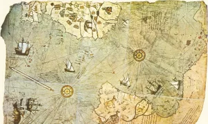 Then, in the 1920s, in the wake of the national upsurge, it was especially important for the Turks to emphasize the role of the Turkish cartographer in creating one of the earliest maps of America. The map began to be closely studied, as well as the history of its creation. And here is what has been revealed. In 1513, Admiral of the Turkish fleet Piri Reis completed work on a large map of the world for his geographical atlas Bahriye. He himself did not travel much, but when compiling a map, he used about 20 cartographic sources. Of these, eight maps belonged to the time of Ptolemy, some belonged to Alexander the Great, and one, as Piri Reis writes in his book The Seven Seas, “was recently compiled by an infidel named Colombo.” And then the admiral says: “An infidel named Colombo, a Genoese, discovered these lands. A book fell into the hands of the named Colombo, in which he read that on the edge of the Western Sea, far in the West, there are shores and islands. All kinds of metals and precious stones were found there. The aforementioned Colombo studied this book for a long time … Colombo also learned about the passion of the natives for glass jewelry from this book and took them with him to exchange them for gold.